
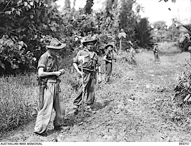
To be honest, I was looking for something else entirely in the Australian War Memorial’s catalogue when this photograph stopped me, dead in my tracks.
This is not Kokoda, but it could be.
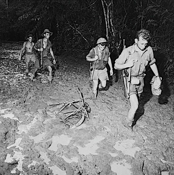
What I wanted was field surveyors in New Guinea ~ men with theodolites, making topographic maps of the infamous route from Owers’ Corner to Kokoda Station. Very few images exist, I know that. What popped up instead were two gunners of 2/6 Survey Battery on a muddy track near Wewak in July 1945. Surveyors, says the caption, and quite right too. But not mapping the landscape. These chaps were measuring it for the guns, fixing exact positions so the 25-pounders knew where they stood and where to aim. Same mud, different job. Not, strictly speaking, the surveyors I was looking for.
Still, the caption is admirably precise: Gunner Sands is measuring by chain to a wad ~ a white survey marker ~ set by Gunner Brown. So I looked for the chain. Sands has something in his hands, Brown stands by his marker, and two men further back have one eye each on the jungle. I believe in the chain, because the caption says it’s there, but I’ll be darned if I can see it. That’s no slight on the archivist who’s written the caption ~ the sleight of hand is ours. When we’re told what’s in a photograph, our eyes go looking for it. And when we’re told what’s on a map, we take that on trust, too.
We’ve all been told it’s the Kokoda Track. We’re all used to reading about the Kokoda Trail. Nobody’s decided which is right ~ perhaps because nobody knows. Australians have argued about it for decades, and even the official history of the Papua campaign didn’t settle the matter ~ but more of that later.
For any surveyor, chain in hand, hacking through jungle-green toward Kokoda in 1942, the words for use later mattered little at the time. There is a difference, though.
THE ROAD
Kokoda sits in the Yodda Valley, in the northern foothills of the Owen Stanley Range, about 1,200 feet up. In the 1940s it was home to a Papuan administration post, a rubber plantation, and the only aerodrome between Port Moresby and the north coast. The 96-km route over the mountains from Owers’ Corner was the main way across for troops, and in places it was, as one brigadier put it, a ‘mere goat track’.
You walk a trail, you cut a track. Before the war it wasn’t a track or a trail. It was a road. Colonial Papua called any regularly used path a road, and the annual report for 1921–22 describes a pedestrian road over the Owen Stanley Range ~ which tells you how much wheeled traffic anyone was expecting.
It had been in regular use for nearly forty years, and in all that time it had never bothered to follow the contour of a spur. It pauses on a crest, then plunges down the far side. It’s hemmed in by dark trees, and doubles back into the bed of a stream to wander along it for a couple of miles. Both words, track and trail, seem generous.
But the name Kokoda Road was still in use in 1942, and two of the men who wrote it down belonged to the 3rd Battalion.
The 3rd was a militia unit ~ part-time citizen soldiers rather than AIF volunteers ~ from south-east New South Wales, known as the Werriwa Regiment. It reached Port Moresby on 27 May 1942 and promptly went down with measles and mumps, which put a third of its men into quarantine. On 22 June, two companies were ordered forward to Kokoda. The order was cancelled the next day because so many were ill, and a company of the 39th Battalion went instead. So it was the 39th, not the 3rd, that met the Japanese first.
Measles, of all things.
Two of the 3rd’s lieutenants had already gone ahead. On 13 June, travelling with a company of the Papuan Infantry Battalion, Lieutenants Young and Palmer walked into the jungle from McDonald’s Corner, where the road proper ended. They were among the first Australian officers to walk the route. Their job was to find places to hold against an attack from the north coast, and judge whether a road could be built.
It took them three weeks and a bout of malaria. The path was wet and slippery with roots, sometimes two feet wide, sometimes only six inches, and the canopy brought visibility down to ten yards or less. But they picked out three places to hold ~ Deniki, Isurava and Eora ~ two of them became major battles, and their sketchmap labelled the route the Kokoda Road.
THE TRACK
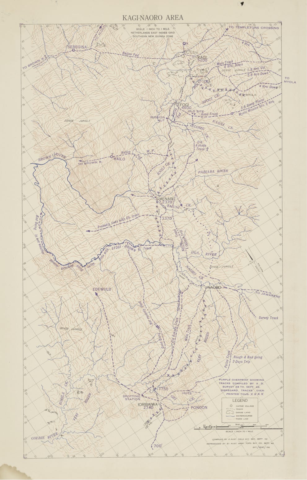
Later, when the 25th Brigade carried a one-inch Kagi–Naoro Area map sheet over the range in September and October 1942, they read Old Kokoda Track, Main Track, and even Police Track. Prepared by 2 Aust Field Svy Sect, brown lines look like contours but the legend calls them form lines ~ a draughtsman’s impression of hills, pieced together from patrol reports and a view from the air, not a measurement on the ground. Spot heights are few and far between: Kagi 5200, Efogi 4600, Menari 2370.
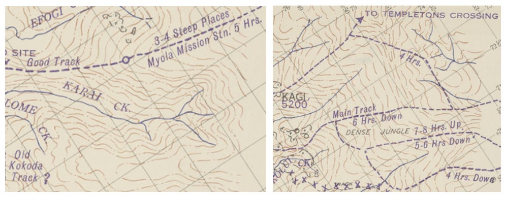
What the sheet does measure is time. Main Track 6 Hrs. Down, says a note below Kagi. 7–8 Hrs. Up, 5–6 Hrs Down, says another on the way to Myola. South of Nauro, the track is Rough & Bad Going, 2 Days Trip. A map that measures the ground in hours is a map that tells a man to brace himself, and I’ve included the full Kagi–Naoro sheet at the end of this piece, so you can pore over it too.
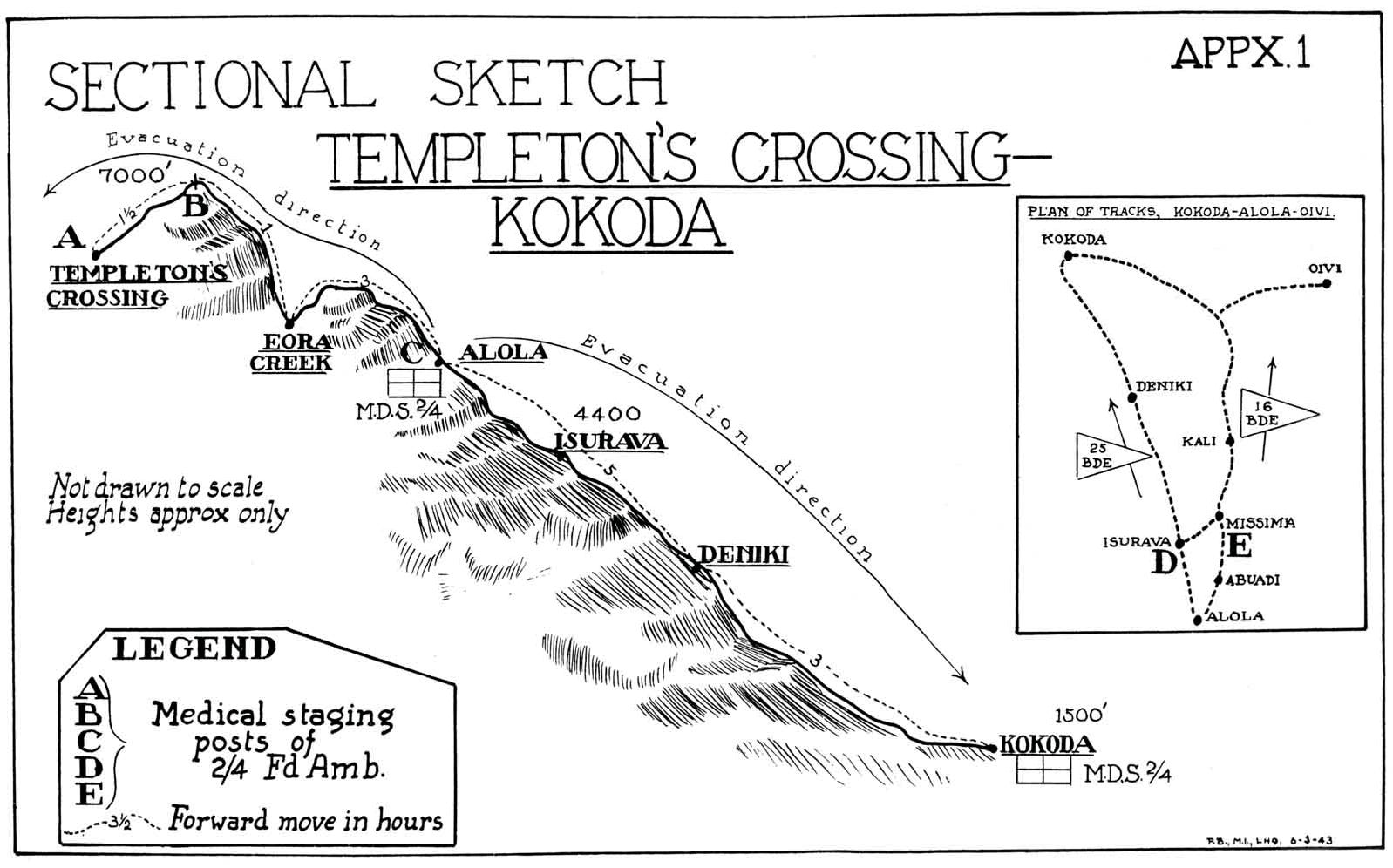
Medics travelled and measured the same jungle route. In March 1943, the 2/4th and 2/6th Field Ambulances drew sectional sketches, from Ilolo all the way to Kokoda, to map their staging posts. Every legend carries the same line: Forward move in hours.
THE TRAIL
So where did trail come from? The Americans get the blame for a lot of things in the Second World War, and they may have to carry the can for this one too ~ though the Australians did their best to help.
Picture Port Moresby in October 1942. Geoff Reading, an Australian war correspondent, is filing copy on a campaign with no settled name, over communications so primitive that every word has to be spelt out. “I got sick of typing descriptions such as ‘Imita–Ioribaiwa–Nauro track’,” he said later. “I called it Kokoda Trail to save typing … I liked the word.” His story, filed on 26 October, ran in Sydney’s Daily Mirror under the headline Kokoda Trail … a Diary of Death.
He wasn’t the first, mind you. The Sydney Morning Herald, the Daily Telegraph and the Argus had all used trail six weeks earlier. The likeliest source is MacArthur’s headquarters, whose communiqués those papers relied on. So it was the Americans after all. Sort of.
After the war, trail became official. In May 1947 the battle honours committee proposed the Battle of the Owen Stanleys, soon tidied up to the Battle of the Owen Stanley Range. By June 1948 it had become Kokoda Trail, for reasons nobody seems to have written down.
The name stuck. Ten infantry battalions and the Pacific Island Regiment carry the battle honour Kokoda Trail, though the 39th Battalion Association tried, and failed, to have it changed to Kokoda Track. In 1972 the route from Owers’ Corner to Kokoda was gazetted as the Kokoda Trail. And in 1997, when the Australian War Memorial counted the unit histories, mostly written by men who’d been there, trail beat track by more than two to one. Men who’d said track in 1942 later wrote trail. Make of that what you will. By 2009, mind you, the Papua New Guinea government preferred Kokoda Track.
For more detail here, by the way Dr Karl James’s The Track: A Historical Desktop Study of the Kokoda Track, written for the Australian War Memorial, is well worth reading.
THE MAP
But this brings me back to the official history. Volume Five of Australia in the War of 1939–1945 is a first port of call for many, and an official history has a ring of truth about it. Its Kokoda chapters, published in 1959, do their level best: 79 tracks in the text, and only two trails.
Now picture the official historians’ office in the 1950s. A draughtsman, Hugh W. Groser, was tasked to provide the mapping for every volume of that history ~ hundreds of maps. No mean feat. Bill Sweeting, the project’s senior research officer, recalled finding Groser asleep at his desk, pen in hand, and then conceded the odd slip might have been made. One such ~ a lapse of concentration that once turned the Red Sea into Red Hill ~ was only just caught in time on a final proof.
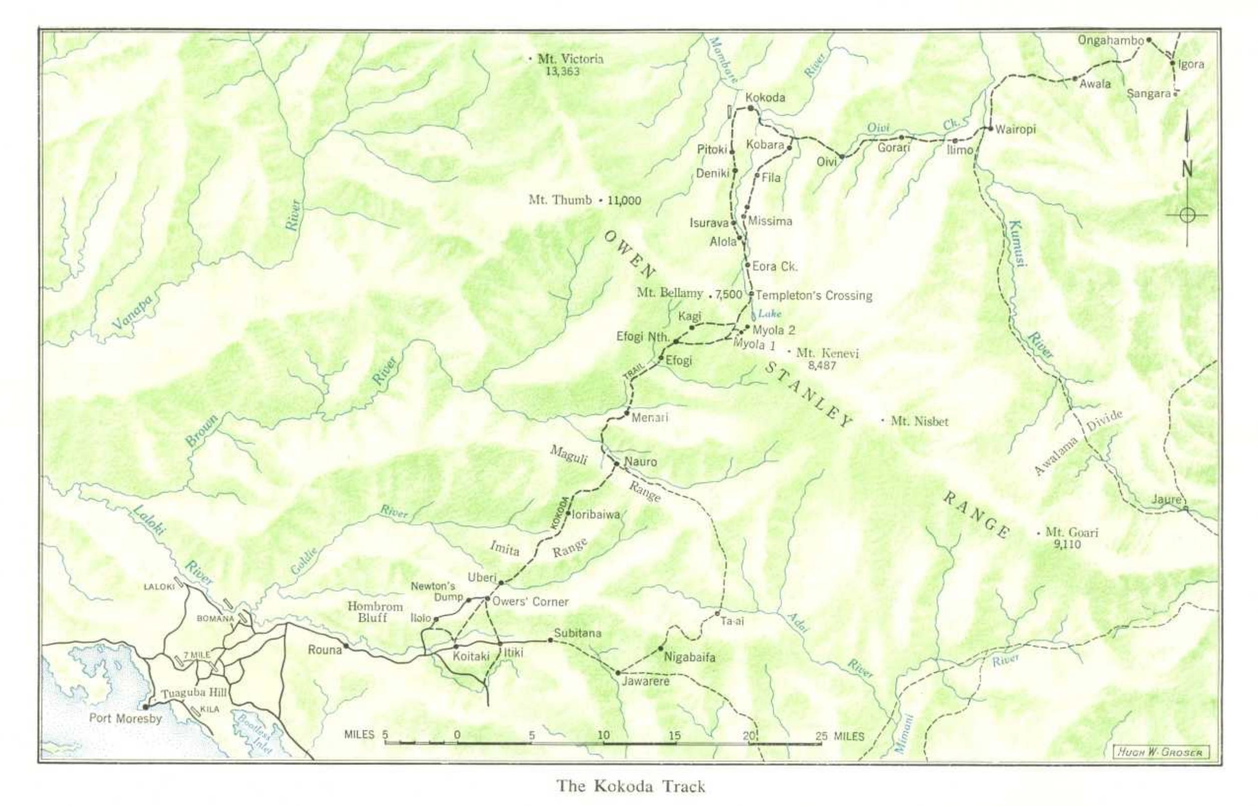
The trouble with the Kokoda map wasn’t a slip of the pen at all. It was timing. By the time the historians had settled on track, Sweeting explained, Groser had already printed his neat little place-name labels, ready to stick down on the map facing page 114. Tiny labels. Barely visible. And they said trail.
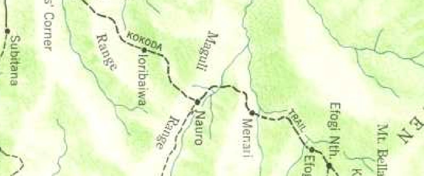
Seek those labels out now, and you will find ‘KOKODA’ hovering a couple of inches up from the scale-ruler on the page, while the word ‘TRAIL’ ~ lost in the jungle ~ sits on the other side of the Maguli Range. But the label for the map itself still says Kokoda Track, and that is what was published ~ the definitive, authoritative account of the route from Owers’ Corner to Kokoda Station, carrying both names into posterity.
Track or trail, it hardly matters to the men who walked it, carried it, or didn’t survive it ~ Australians, Papuans and Japanese alike.
Like the chain that’s supposedly in Gunner Sands’ hands, some things we take on trust. A name on a map isn’t one of them. It’s a decision someone made at a desk, often in a hurry, and it lasts far longer than they ever meant it to. So I’ll say track, because that’s what was written on the maps the men carried in 1942. And I’ll say trail when I mean the battle honour, because that’s the name they earned.
Track or trail ~ which do you say, and why?
Excellent stuff!
That moment of being stopped in your tracks by something you weren't even looking for is one I think a lot of us know, and how fitting that it led you to a muddy photograph of two gunners near Wewak. I really enjoyed how you followed one small word all the way through the records: the 1921–22 pedestrian road over the Owen Stanleys, Geoff Reading typing Kokoda Trail simply to save himself the keystrokes, and the Kagi–Naoro sheet measuring the ground in hours rather than distance, with that line about Rough & Bad Going. If you ever feel like reading from the opposite corner of the country, I'd be glad to have you stop by my profile, I write from Karratha in the Pilbara.
All my articles: https://lukeybkarratha.substack.com/archive