
Yesterday, I was tidying my bookshelves, which in practice means moving books from one pile to another and reading half of them at least, on the way. A thin, softbound, beige book stopped me: On se bat à Montélimar, by Robert Vernin. “They’re fighting at Montélimar.” Printed in Valence in May 1945, with the war in Europe barely over, it’s a little publication that gathered anecdotes ~ so recent, they were more conversations ~ episodes of occupation and liberation in the town and the countrywise around it.
The prose has not aged well. But between the pages is a hand-drawn sketchmap, and the moment I opened it at that page, I knew where everything was. That set me thinking, because I also have official mapping, and the two could hardly be less alike.
THE OFFICIAL MAPS
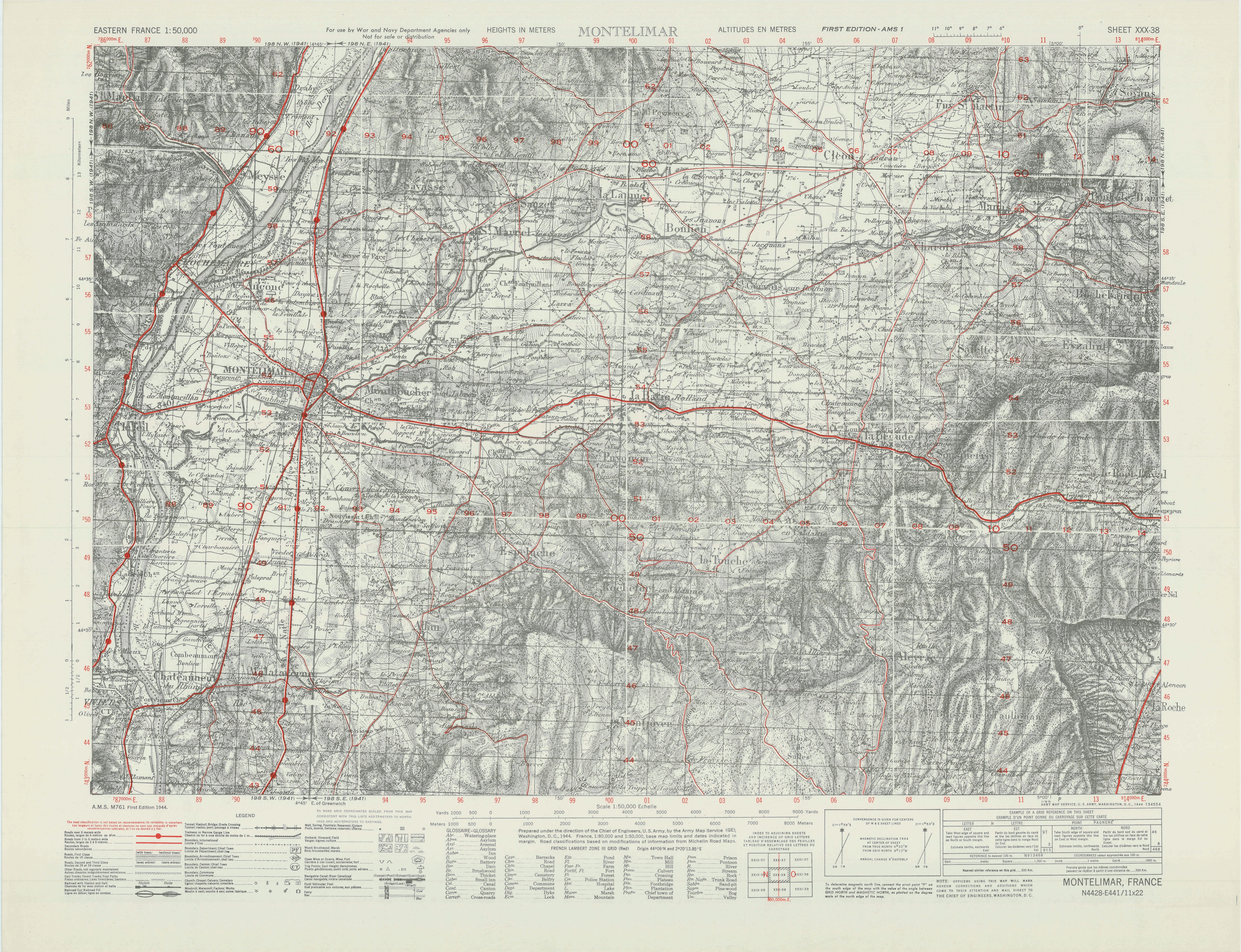
This map is what an American officer would have unfolded, come rain or more rain, in the south of France in August 1944. The margin tells us it was “prepared under the direction of the Chief of Engineers, U.S. Army, by the Army Map Service, Washington, D.C., 1944”, and it was “for use by War and Navy Department Agencies only”. That’s always amused me, as I cannot for the life of me image Il Partisano or Elle Maquisard meekly re-foloding any map sheet and handing it over, should they ever find one by accident.
Heights are in metres. A French Lambert Zone III grid is overprinted in red so that a gunner could work out useful references. The roads, also in red, were classified from Michelin road maps, which is a pleasing admission of fault: a husband and wife with a picnic basket and a charabanc would have been less likely to get lost than an army.
Underneath the red, though, the Americans drew almost nothing. The margin says the base was French topographic mapping at a scale of 1:80,000 and 1:50,000, and it names sheet 198 as its source, each one of four quarters dated 1941. That is the Carte d’État-Major, the French staff map, enlarged ~ a nineteenth-century monument to military mapmaking if ever there was on. The Dépôt de la Guerre began trials in 1818; army officers surveyed the nation at a scale of 1:40,000, and the results were engraved on copper at 1:80,000 in 273 sheets. France is not a small nation. As you might imagine, that took a while. The entirety of the country wasn’t fully published until 1875, when the first attempt to show its relief provided hachures to make the point: short strokes running straight down a slope, packed closer and heavier as the ground steepened. Scattered among them were spot heights, single figures in metres fixed by surveyors on summits, cols and crossroads – so the hills east of Montélimar appear as dark, furry caterpillars, and the Rhône plain is just a piece of blank paper.
Hachures do give a vivid impression of shape. What they cannot provide is confidence between spot heights, which is a bit of a disadvantage if you’re a tank commander.
You can see that a slope on tomorrow’s planned line of attack is steep; you cannot read off how steep it will be, when – or if – you tackle it. Contours are a much better solution, and by 1944, they were, thankfully, almost a standard addition to most new mapping. Yet here, in the year of the invasion, and pretty much a product for the purpose therein, the maps issued for that fight still carried the hachures of a century before. There had been no time to resurvey the Drôme, so Washington reprinted what Paris had engraved.
THE SKETCHMAP
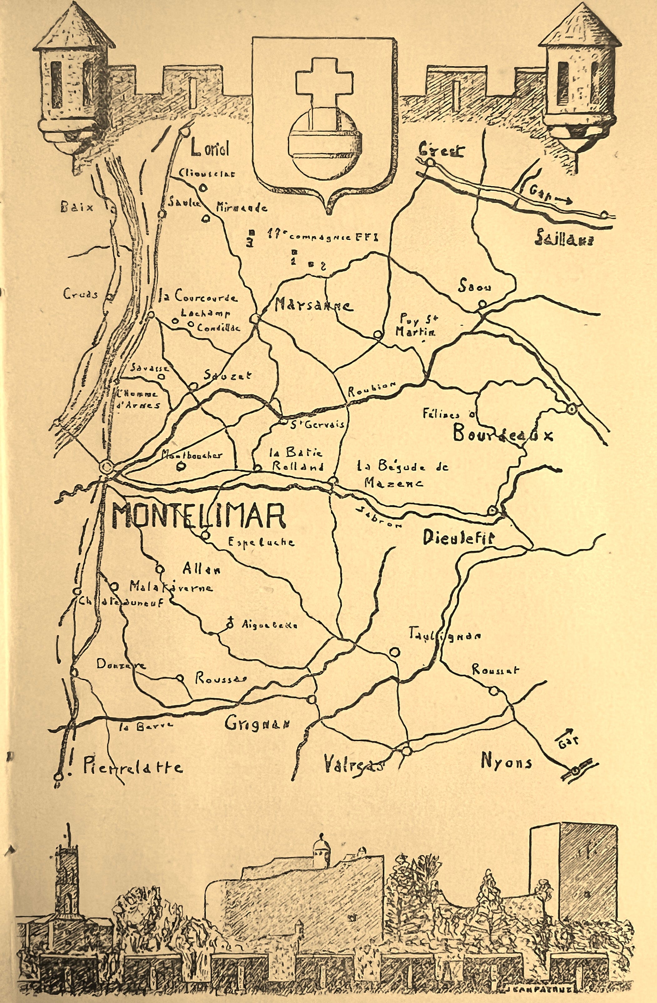
Now the other map, the sketchmap inside the book. It has no scale, no grid, no north point, not a single hill, and this is NOT a comparison - no serious tank commander would have depended on such a thing, though more than one senior officer might have found it useful to help explain his thinking.
The Rhône is a braid of pen strokes down the left edge. Roads are single wobbling lines and villages are small circles with hand-lettered names. Two rivers are named, the Roubion and the Jabron, while simple arrows at the edges point away, and off, to Gap. The artist couldn’t resist adding some decoration, but that’s what artists do. Battlements and turrets run along the top, with the town’s arms between them, an orb topped by a cross. Along the foot is the Montélimar skyline, the castle and its square tower above the rooftops. It is as much a bookplate as it is a map; it’s an echo of war, not a tool for it ~ and yet, curiously, it’s brilliant. Or I think so, at least.
MONTELIMAR is written three times larger than anything else, so the eye is drawn there. Names fall into place: Loriol and Crest across the top, Dieulefit and Bourdeaux to the east, Grignan, Valréas and Nyons along the bottom. Just south of the town are Allan, Malataverne, Châteauneuf and Aiguebelle. Up-river are Savasse, La Coucourde and Saulce. A small flag north of Marsanne marks the 11th Company of the FFI, the French Forces of the Interior -- the sketch puts the whole theatre on a page, which is far, far, more helpful to anyone trying to understand the locations within this terrain.
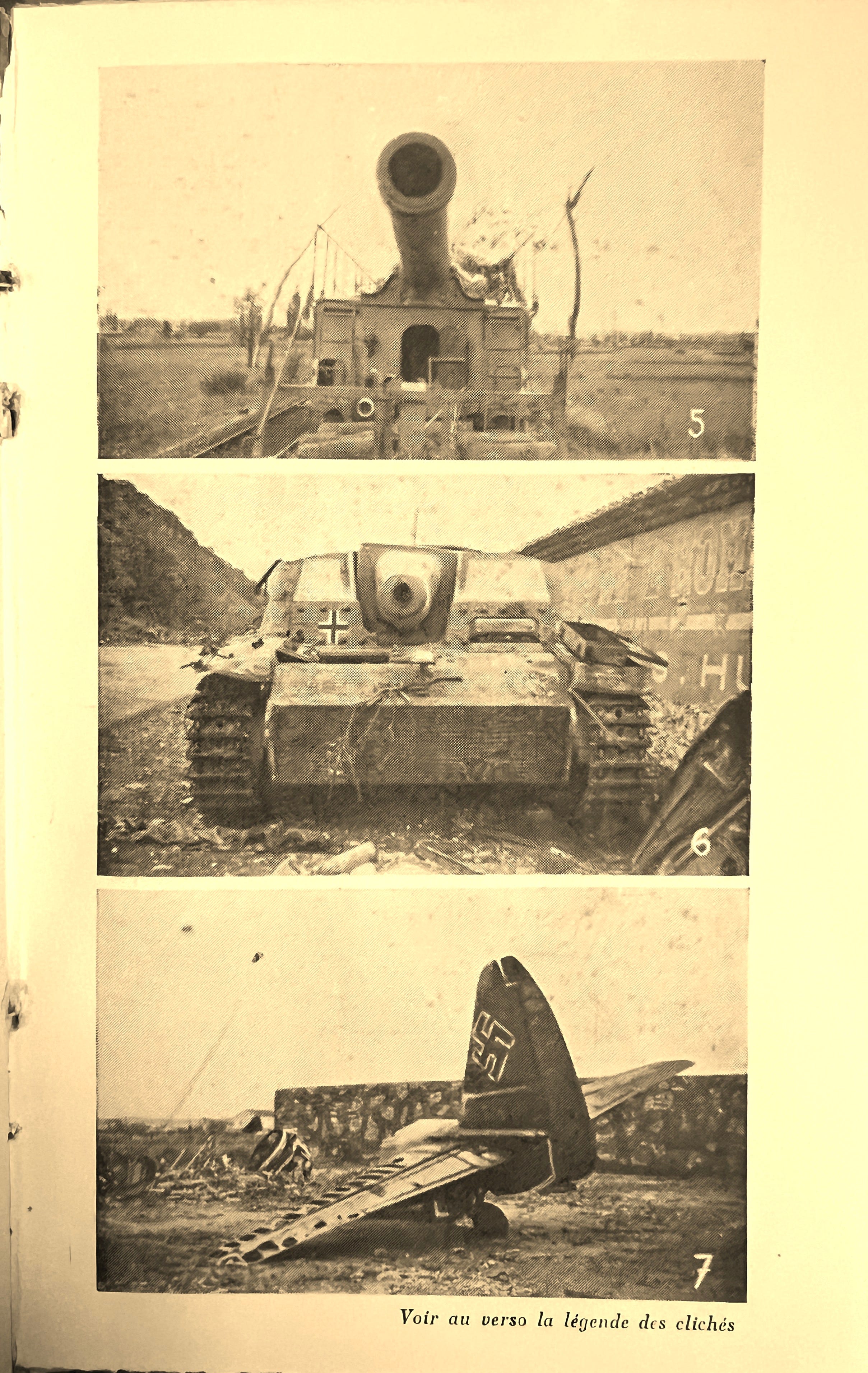
The odd photographs in this book fill in many blanks. Their captions, translated:
5. A heavy artillery piece on rails near Saulce (two are in Montélimar station, four at Livron). Photograph by Dr Cochinard, army medical captain at Valence.
6. One of the many Tiger tanks abandoned by the Germans or destroyed by the Americans. Photograph by Dr Cochinard.
7. On the airfield at Ancône, near Montélimar, one of the Junkers 88s destroyed by American “Lightning” fighters on 15 August 1944. Photograph by Dr Cochinard.
And a small footnote to number 6: to my eye, that’s a turretless assault gun, not a Tiger tank. But then, by 1945, every German tank was a Tiger to those who’d watched them pass; and every dark and pistol-pocketed long-coat was worn by an SS officer, whether or not he was a card-carrying member of that establishment.
SO WHAT HAPPENED, WHERE?
The sketchmap is the echo of a topographic base map, ululating through the spring and summer of 1944. Long before the Allies landed in Provence ~ Operation DRAGOON, that August ~ local FFI companies and maquis groups were already harassing German forces and punishing collaborators along the strategic Rhône Valley corridor.
Put your finger, as I did, on the sketch just to the south of Montélimar, and one of the worst, best-known events in this region can be followed place by place.
On 30 March 1944, just before dawn, men of the 103rd FFI group were gathered at the railway station of Châteauneuf-du-Rhône, drawing petrol from a tank wagon. They’d been camped for about three weeks in two small farms, nestled on the wooded hill-side between Allan and the abbey of Aiguebelle: one called Nazareth ~ belonging, not surprisingly, to the monks ~ the other, the long-abandoned Laurent farm at l’Aubagne.
A car passed them, travelling almost silently with its lights out. It slowed a little, then turned, and returned towards them. The automatic weapons opened up, and the men of the 103rd FFI group had nowhere to hide. One volunteer silenced the attackers with grenades; Lieutenant Marcel Delaby was killed and Lieutenant Daniel Quineaud, badly wounded, was captured. Survivors fell back to the two farms. The Waffen-SS ~ these men were Waffen-SS ~ followed them up the hill, where the young men held out until their ammunition was gone.
That afternoon, the people of Allan watched those men as they were marched in to the village, chained, one to the next. The book, On Se Bat a Montelimar, explains how they were lined up against a wall at the village school, and the mayor, his deputies and a local constable were fetched to act as witnesses. The parish priest was away, so the Abbé d’Yvoire was called in from Espeluche. He spoke with each man, took their last messages, and then offered himself to the SS commander in their place. The officer declined, thanked him, and made a short speech regretting the necessity. The men were shot in threes, in the back. Vernin lists ten dead from the day, most of them from Lyon, one from Montélimar. He has the wounded Quineaud killed at the same wall, though the Musée de la Résistance en ligne places his death at Viviers, across the river. All ten are honoured, though, in the cemetery at Allan.
Châteauneuf, Allan, Aiguebelle, Espeluche ~ four circles on the sketch, no more than a thumb’s width apart, and the whole sequence of events becomes clear.
August 1944: the battle square
Now move your finger to the north. On 15 August, the Allies landed in Provence, and that same day, according to the book’s anecdotes at least, American Lightnings shot up the Junkers on the airfield at Ancône. The German 19th Army, under General Wiese, started pulling back, up the Rhône ~ making use of the only good road in the region, the N7, which squeezes between river and hills north of Montélimar.
General Truscott of the US VI Corps sent a fast column through the mountains, with the aim of cutting off that direct line of retreat: Task Force BUTLER. On the evening of 20th August, Butler was ordered to seize the high ground just north of the town. By the 21st his men were at Crest and on the ridges above the river ~ the US Army’s official history calls the ground a ‘battle square’: the Drôme to the north, Rhône to the west, Roubion to the south, about 250 square miles. Look at the sketchmap and there it is, drawn by a Frenchman who’d never heard the phrase. Loriol and Crest along the top, the Roubion runs across the middle, and Marsanne, Sauzet, Condillac and Puy-St-Martin lie inside.
The fighting ran for a week, and the 36th "Texas" Division under General Dahlquist came up to reinforce Butler. Against them General von Wietersheim’s 11th Panzer Division fought to keep the corridor open. On the 22nd the Germans briefly took Puy-St-Martin and cut the American supply road. On the 24th they captured a copy of Dahlquist’s plan. On the evening of the 25th American infantry came down from Condillac and blocked the N7 at La Coucourde. Around midnight Wietersheim led a scratch force in person and broke the block. The Americans never did close the road. They shelled it instead. The 36th Division’s own account records more than 75,000 rounds fired, and claims 11,000 German casualties, 2,100 vehicles and 1,500 horses, with wreckage for sixteen miles. It also counts six 380 mm railway guns. Dr Cochinard’s caption counts them too: two at Montélimar station, four at Livron. Montélimar itself was free on 28 August. Much of the Nineteenth Army got away across the Drôme, but in doing so, it also left much of its transport behind – not needing any map, never mind an accurate one.
WHAT A SKETCHMAP CAN DO
The official map sheet tries to answer questions a soldier might ask. How steep is this hill, where is that bridge, what is my grid reference? It is a remarkable object, showing the work of French surveyors, a century before. But to me, the sketchmap better answers the question a stranger asks first: where is everything, and what is next to what? Someone drew only what mattered to the story and left the rest of the Drôme as white paper. That choosing is the skill: it is useful to know what the task in hand might be, and a map doesn’t always need to be detailed, to be helpful.
I’m still not sure which I prefer, the sketchmap or the map sheet. I shall put the book back on the shelf, eventually, probably, and have to make up my mind.